March 14, 2007

Graham and Metropolitan

70 years on, all of the buildings in Berenice Abbott's photo of Graham and Metropolitan remain, but the view sure has changed. Amazingly, there is still a lot of architecture left behind many of our faux-clad buildings. Here, though, the cornices and tower have been lost.

Besides the massing of the buildings themselves, about the only constant is the signage on the corner building.

abbott_graham_metro.jpg
Metropolitan and Graham Avenues, ca. 1937.
(Berenice Abbott)


Graham_Metro.jpg
Metropolitan and Graham Avenues, 2007.
(Photo: WPA)


April 3, 2007

Arion Hall

Arion Hall, once home to the Arion Singing Society, is one of many remnants of Bushwick's once-thriving German population. The building sits on Arion Street (formerly Wall Street), between Broadway and Bushwick Avenue/Beaver Street. While the building today is no match for its past glory, its recent renovation as the Opera Lofts is a vast improvement over the sorry state it was only a few years ago (click down to the end of the page).

The small Second Empire to the left of Arion Hall is gone - only its ghost remains. The two buildings to the right of Arion survive, enveloped in artificial siding. Still, its apparent that many of the features of these buildings survive.

For more about the Opera House Loft conversion, see this thread at Brownstoner (prompted by a lovely mystery image of the building's pressed-metal cornice, complete with lyre).

arion_card.jpg

Arion Hall, circa 1910.
(Credit: Brooklyn11211 collection)


arion_2007.jpg

Opera House Lofts, 2007.
(Photo: WSD)


More information on Arion Hall:
Forgotten New York
Brownstoner
Go there

November 24, 2007

Happy Evacuation Day

liberty_pole.jpg
Raising the Liberty Pole, 1776
Source: Library of Congress

In early America, the 25th of November was traditionally celebrated as Evacuation Day - the anniversary of the day that the British troops left New York City in 1783. Once upon a time, particularly in the New York area, Evacuation Day was considered a more important holiday than Independence Day. New York City had been occupied by the British for much of the war, and they City was the last military post given up by the British upon their surrender.

As the British sailed through the Narrows and out of New York Harbor on 25 November 1783, one of their last sights was that of the American flag flying atop a liberty pole that was raised next to the New Utrecht Reformed Church in what is now Bensonhurst, Brooklyn. (New Utrecht was one of the six original towns of Kings County, along with Brooklyn, Flatlands, Flatbush, Gravesend and, of course, Bushwick.) The sixth incarnation of the New Utrecht liberty stands today in the location of the first liberty pole - at Christopher Columbus Avenue (18th Avenue) and Liberty Pole Boulevard (84th Street).

Erected in 1945, the current New Utrecht liberty pole is 106' high, and is topped by a wooden eagle and weathervane that topped the original pole. It is said to be the last remaining liberty pole in the 13 original colonies. The existing church was erected in 1828, and in 1966 it became one of the first landmarks designated within the City of New York; in 1998, the designation was expanded to include the parish house and the liberty pole itself.

More information:

Liberty Pole and the Battle of Golden Hill (Barry Popik)
Friends of Historic New Utrecht
New Utrecht Liberty Pole Association
New Utrecht Reformed Church
Neighborhood Preservation Center

Thanks to Walter Greenspan for bringing this to our attention.

May 4, 2008

GTM Two Years Later

GTM 2005.JPG
GTM: September, 2005


Last Friday marked the two year anniversary of the Greenpoint Terminal Market fire. Two years later, there is still no sign of development activity at the site. The owner's have cleared the rubble (and sold off the brick and timbers), but no other work has been undertaken.

Gowanus Lounge has a great series of before, during and after photos to mark the anniversary.

May 26, 2008

McLoughlin Brothers

m_goose_small.jpg
Mother Goose in an Airship, McLoughlin Brothers, 1909.
Source: Brooklyn Historical Society

At the turn of the 20th Century, south Williamsburg home to at least two of the country's largest printing houses. The larger of these was D. Appleton & Co., U.S. publishers of the Alice in Wonderland books and The Origin of Species, among many others. Appleton was located on Kent Avenue between Hewes abd Penn Streets; the building was taken down for the construction of the BQE. The second publisher - McLoughlin Brothers - was located on South 11th Street between Wythe and Berry. The McLoughlin plant was constructed in two phases - the original ca. 1870 building is located on the side of South 11th Street at the corner of Berry; the extension, constructed before 1900, is located on the south side of South 11th Street at the corner of Wythe. The red brick buildings still stand, their decorative sandstone or terra cotta trim still legible beneath a layer of flaking white paint. The extension still retains a mansard roof with iron cresting. A pyramidal roof which sat atop the corner pavilion of the original building has been removed, but much of the rest of the buildings are intact (and very rough around the edges). At the moment, the buildings are occupied as artists lofts (have been for decades, we understand) - that may be changing as the building is either changing hands or going through foreclosure.

McLoughlin is the subject of an exhibit now underway at the Brooklyn Historical Society (its been running since last September, and continues through this August). The exhibit includes pop-ups, ABCs, children's "classics," cautionary tales, travel and adventure titles, and Christmas books. BHS has this to say:

This exhibit highlights beautifully-illustrated children’s books, printed in Brooklyn by McLoughlin Brothers, a publisher who pioneered new technology and marketing techniques in the mass production of inexpensive children’s books... Visitors will see children’s classics, such as Alice in Wonderland and adaptations of Robinson Crusoe, educational books, such as The History of the United States in One Syllable, cautionary tales like those in the Little Slovenly Peter Series, ABCs, Mother Goose stories, Christmas Books, books teaching children how to paint or draw, along with games and puzzles.

McLoughlin's success was largely due to the innovations in printing technology and inks that were developed at the South 11th Street plant. As a result of these innovations, McLoughlin was able to put out brightly-colored, visually stunning books and games for children at relatively low cost. As a result of its combination of skillful design, innovative printing and clever marketing, McLoughlin Brothers were practically synonymous with illustrated children's books and games. The company was bought by Milton Bradley in the 1920s, and all of the Brooklyn operations were relocated to Springfield, Mass.

McLoughlin-1895.jpg
McLoughlin Brothers Printing Plant, 1895
View west from Berry Street
Source: King's Views of New York

Current views of the buildings after the jump.

Continue reading "McLoughlin Brothers" »

August 5, 2008

Dunham Place

Forgotten NY has an article today about Dunham Place, one of the two shortest streets in Williamsburg (Fillmore Place being the other). Dunham Place is the one-block street that runs between Broadway and South 5th Street, a block east of Kent Avenue. As Forgotten says, the street opened in 1850 and is home to a number of impressive late-19th century loft buildings. According to an 1827 map of the Village of Williamsburgh, a "Mr. Dunham" (probably David Ross Dunham) owned a large house on the south side of South 7th Street (now Broadway), facing the head of what would become Dunham Place (there is an extremely ugly building there now). This was a stone house originally constructed by a Capt. D. Griswold; Dunham later constructed a larger house, referred to as the Dunham Mansion, north of Broadway - probably in the vicinity of today's Dunham Place.

[As with Fillmore Place, the historic block on which Dumham sits was very large and eccentric to the street grid; it would be interesting to know if the opening of Dunham was a speculative real estate venture as well.]

Dunham Place was not the first street in Williamsburg to be named after entrepreneur and property owner David Dunham. That honor goes to Grand Street, the lower portion of which (i.e., the stretch west of Bedford Avenue) was once called Dunham Street. Actually, that was the second name for Grand Street, as Grand Street from the river to Roebling was laid out as Washington Street in 1812 by Thomas Morrell, one of Williamsburgh's founding fathers. At that time, he also named the spit of land that jutted into the East River (the area just west of Grand Ferry Park today) Morrell Point.

David Dunham purchased Williamsburgh (yes, apparently all of it - which at the time probably meant from Division Avenue to somewhere north of Metropolitan, and the East River to Bedford) at a sheriff's auction in 1818. Dunham's son, David Ross Dunham, opened the first steam ferry service from Williamsburgh to Manhattan. Dunham pere expanded his Williamsburgh holdings in 1821 by purchasing the the farm of John Conselyea, which was located on either side of South 6th Street, from the East River to just east of Berry Street. David Dunham was also responsible for establishing the first school in Williamsburgh, donating a plot of land on the block bounded by North 1st, Berry, Grand and Bedford ("where the old log cabin stood"). There, the Bushwick District School was constructed in a one-story frame building.

August 7, 2008

Most Holy Trinity Church

1.JPEG
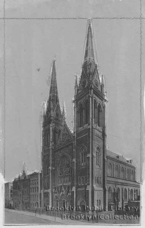
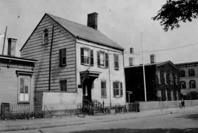
Most Holy Trinity Church, Montrose Avenue
William Schickel, architect
Photo: Brooklyn Public Library

Gowanus Lounge had a post a week or two back about Holy Trinity Cemetery, a small German Catholic cemetery in Bushwick (next door to the larger Cemetery of the Evergreens). The cemetery was originally located behind Most Holy Trinity Church, in Williamsburg.

Now known as Most Holy Trinity and St. Mary*, the parish was originally founded as the German Church of the Holy Trinity in 1841. It was the first National parish in the Brooklyn diocese, and the first German Catholic Church in Williamsburg. It was also the mother church for a host of other German parishes over time. Holy Trinity was founded by Father John Raffeiner, a wealthy doctor-turned-priest from Austria. Raffeiner came to the United States in 1833, settling in New York where, in 1836, he founded St. Nicholas Church on East 2nd Street (the oldest German church in the New York Diocese). Raffeiner is also credited with establishing a German parish in Boston during this period. In 1841, Raffeiner moved to Williamsburg, a village that at the time was seeing a huge influx of German emigrés. There, largely with his own funds, the priest purchased property on Montrose Avenue from Abraham Meserole.

The first church of Most Holy Trinity was a frame structure, completed in 1841. A rectory was constructed in 1844. In 1853, the parish constructed a new church building on the corner of Montrose and Graham (it was for that church that the parish's cemetery was moved). Between 1863 and 1871, Holy Trinity's parish boundaries were divided numerous times - yielding Annunciation (1863), St. Nicholas (1865), All Saints (1867) and St. Leonard's (1872) parishes. Still, the original Holy Trinity parish continued to grow, and in 1880, construction began on a new church (on the site of the original frame church). The cornerstone for the new church was laid in 1882, and the building was completed in 1885. The new church was constructed of Belleville (N.J.) brownstone, with two towers of 250' each and a 70' tall nave (the spires, also constructed of brownstone, were covered in lead sheets in 1990).

The architect for the new church was William Schickel. Schickel was active in the late 19th century; he designed a number of churches and German-related structures in New York and Brooklyn. Among his more prominent works are the Century Building on Union Square (now home to a Barnes & Noble), the Freie Bibliothek und Lesehalle on Second Avenue (now the Ottendorfer branch of NYPL) and, next door, the German Poliklinik (now the Stuyvesant Polyclinic Hospital)

Betty Smith (née Elisabeth Wehner), author of "A Tree Grows in Brooklyn" was baptized at Holy Trinity in 1897. In her novel, the church is described as "the most beautiful in Brooklyn... it was made of old gray stone and had twin spires that rose cleanly into the sky, high above the tallest tenements".

The parish's property encompasses much of the block bounded by Graham, Johnson, Manhattan and Montrose. It includes the former Catholic Orphan Asylum on Graham Avenue (erected between 1865 and 1885), two school buildings, a rectory and a faculty residence. The rectory which appears to have been constructed in 1872 (Joseph Berendach, architect), is located immediately east of the church. The elementary school is located to the east of the rectory; constructed in 1888, it was, prior to its closing in 2005, the oldest parish school in Brooklyn. The high school, which closed in 1972, was located on Johnson Avenue. In the 1880s, the church's two schools enrolled 1,600 students. The faculty residence, at the corner of Montrose and Manhattan, was designed by Beatty and Berlenbach in 1952. In addition to the buildings on its block, Holy Trinity was responsible for the construction of the original St. Catherine's Hospital, on Bushwick and Devoe.

Most Holy Trinity & St. Mary Church is just one of many significant remnants of Williamsburg's German past. The building itself, together with its associated structures, is a landmark in every sense of the word. With the recent merger of Most Holy Trinity and St. Mary, MHT's might seem secure. But its roll of parishioners (now almost exclusively Hispanic) continues to dwindle, and most of its associated structures sit vacant. With any luck, the rectory, elementary school, asylum and faculty residence will find new and compatible uses.

*Most Holy Trinity merged with Immaculate Conception of the Blessed Virgin Mary Church in 2007. St. Mary's was founded in 1841 as an Irish church, and was located at Leonard and Maujer Streets.

Sources:
Most Holy Trinity - St. Mary: History
Most Holy Trinity - St. Mary: Tour of the Church
New York Architecture Images
BushwickBK - Bushwick Geographic: Most Holy Trinity Cemetery
Smith, Betty A Tree Grows in Brooklyn
"Five Years in Building: The New and Handsome Church for German Catholics in Williamsbug." New York Times, August 24, 1885, page 8.
100th Year Marked by Brooklyn Church." New York Times, October 13, 1941, page 12.
"Catholicism: A Significant Page of Local History." Brooklyn Daily Eagle, April 1, 1877, page 4.
"Local Improvements." Brooklyn Daily Eagle, July 26, 1872, page 3.
"A New Parochial School." Brooklyn Daily Eagle, May 14, 1888, page 6.
"Building Plans Filed." New York Times, June 23, 1952, page 32.

More photos after the jump...

Continue reading "Most Holy Trinity Church" »

September 19, 2008

The Glass Stampede

beforeafter_odm.jpg
80 Metropolitan (from New York).
Credit: Courtesy of Lou Madigan (l); courtesy of Kim Wendel Design LLC (r).

New York's Justin Davidson has written a long and thoughtful piece on the architectural transformation of New York City these past few years (its a week or two old by now, but we're just getting around to it). The article includes before and after pictures of 54 of the 76,000 (!) new buildings constructed since 1993, as Davidson attempts to answer the question "has this ferment improved New York or eaten away at the city’s soul?". In the end, Davidson concludes that while "[it] would be wonderful if we could stem the Avalonization of New York simply by demanding better buildings... (Good Design Now!)", "most architecture in any age is crap, and today’s crap isn’t as bad as yesterday’s". Based on his analysis, we can buy that, though his thesis certainly applies better to Manhattan than Brooklyn. Why does Brooklyn (and LIC) get all the missed opportunities?

All in all its a very good article - the more so because we tend to agree with most of his calls. Both the good (Rossi's Scholastic, ShOP's Porter House, Nouvel's 40 Mercer and Piano's Morgan Library to name a few); and the bad (of course, Greenberg Farrow's Dutch Mustard 80 Metropolitan, Gruzen Sampton's J Condo, O'Hara's Ten63). On Dutch Mustard, Davidson has this to say:

Rather than renovate, Steiner NYC tore down the rather fancy Old Dutch Mustard plant and worked up a new six-story residential complex, currently under construction. There is no evidence that it will be marvelous enough to take the bite out of the loss.

We couldn't have said it better (though we have certainly said it fairly often).

November 8, 2008

Re-Brooklyn

Corner Market 1935.jpg
Graham & Metropolitan
Photo: Percy Loomis Sperr (1935)
via re-Brooklyn

Re-Brooklyn is a new website with some nice Brooklyn then-and-now photos. When we saw this photo, we thought we had already been there back in March of 2007, but as it turns out, there's more than one vintage photo of the corner of Graham and Metropolitan. For the record, re-Brooklyn's photo is by Percy Loomis Sperr (taken in 1935); our photo is by Berenice Abbot (taken in 1937). Between the two photos, the advertising on the side of the building changed.

We've been collecting then and now photos of our own, and are planning on restarting the tradition, so stay tuned.

January 4, 2009

Playground on Kent

Kent playground.jpg
"Waterfront basketball--A spacious Park Department playground on Kent Ave. at the foot of Broadway provides ideal athletic facilities in the very shadow of Williamsburg Bridge."
Caption & photo: Brooklyn Public Library

Effective Saturday, East River State Park is closed for the season. State Parks had been saying they were going to do it, but there was some hope that a deal might be reached to keep it open. We hear that both Friends of BEDT Park and Assemblyman Lentol are still working to reach a deal that would allow public access to the only significant waterfront open space in all of north Brooklyn. Meanwhile, all of the other state parks in NYC (including Fulton Ferry in Dumbo) remain open.

Coincidentally, we came across this picture while trolling the Brooklyn Public Library's website this evening. Taken in 1950, it shows a former NYC Department of Parks playground on Kent Avenue between Broadway and South Sixth Street. The site is now home to a city DOT facility. Even more coincidentally, this is the exact same location that OSA and others have proposed DOT turn over to Parks in order to create additional waterfront open space. If it ever came to pass, it would provide a nice terminus to the proposed Domino espanade.

January 30, 2009

This Day in History - USS Monitor Launched

monitor.jpg
USS Monitor, Watercolor by Oscar Parkes (via Wikipedia)

Today marks the anniversary of the launching of the USS Monitor, the first iron-clad warship of the U.S. Navy, from Greenpoint's Continental Iron Works. The (new) Brooklyn Eagle has a nice little write up of the Monitor. Wikipedia also has a long article on the ship, including the above image (which we like because its one of the view pictures of the Monitor that gives one a sense of the scale of the vessel - it was not small).

Continental Iron Works was located near the Bushwick Inlet, roughly where Quay Street meets Franklin Street. The buildings of the ironworks are long gone. There is a museum dedicated to the history of the vessel - it is currently without a home, although hopefully someday soon it will open as part of Bushwick Inlet Park (where exactly is a matter of some controversy).

March 9, 2009

North Brooklyn Story Project

NBSPLogo_sm.jpg

NAG (Neighbors Allied for Good Growth) has been doing a series of town hall meetings over the past few months, trying to get people engaged on different aspect of life and activism in Williamsburg and Greenpoint. One of the projects to come out this is the North Brooklyn Story Project, which seeks to compile an oral history of the neighborhood and its denizens. They're having a meeting for volunteers this week (Wednesday the 11th), in anticipation of a training session at Brooklyn Historical Society later this month.

What: North Brooklyn Story Project Introductory Meeting
When: Wednesday, March 11th, 7 p.m.
Where: Neighbors Allied for Good Growth headquarters: 101 Kent Avenue at 9th Street

The North Brooklyn Story Project is looking for people with stories to share about our community, and people who can listen to and record these stories.

Do you have a story to tell about life in Williamsburg or Greenpoint? A memory, a snapshot of life here today, an interesting interaction with community members? Do you know a neighbor or shopkeeper or friend with a story to tell? If so, you're invited to become part of the North Brooklyn Story Project.

The first step? To find people interested in telling their stories and people interested in interviewing them. Together, interviewers and storytellers will create an archive of North Brooklyn stories that all of us can use to feel connected to our diverse neighbors and neighborhoods – past, present, and future.

No special skills or equipment required – just ears and a voice. If you're interested, please come to the North Brooklyn Story Project Introductory Meeting, on Wednesday, March 11th, at 7 p.m. The meeting will take place at NAG headquarters (101 Kent Avenue at North 9th Street). At the meeting, we’ll discuss an upcoming training to be offered to our group by the Brooklyn Historical Society, as well as your ideas for making the project a success.

For more information, please contact Gregor (g [dot] nemitzziadie [at] gmail [dot] com) or Rachel (rachtree [at] gmail [dot] com).

March 19, 2009

North Brooklyn Story Project

NBSPLogo_sm.jpg

The North Brooklyn Story Project is a project of NAG's Community Character working group. This group is putting together an oral history project, and will be offering a free training session for volunteers this Saturday morning at the Brooklyn Historical Society. If you are interested in being an interviewer for this project and would like in Saturday's training session, contact Grégor at g.nemitzziadie [at] gmail [dot] com.

March 26, 2009

Bushwick in Williamsburg

On Saturday, historian John Dereszewski will be leading tour of Bushwick Avenue from Graham to Flushing. This is the part of Bushwick Avenue that was the center of the original Bushwick settlement, but which later became part of the City of Williamsburg.

Via Bushwick BK, which has all the details.

April 17, 2009

Then & Now: Havemeyer Sanitary Market

Havemeyer_Market.jpg
Havemeyer Sanitary Market
Source: Brooklyn Public Library


165_Havemeyer.JPG
165 Havemeyer Street
Photo: brooklyn11211.com

The above photo is a view north on Havemeyer Street between South 3rd and South 2nd Street, circa the 1940s. The Havemeyer Sanitary Market was a public market constructed by the City of New York in 1939 or 1940, and was intended to replace pushcarts on the streets of the neighborhood (pushcarts, or the elimination thereof, were a particular obsession of Mayor Laguardia).

To the right is a picture of the site today, complete with a building that brooklyn11211.com calls "soul-deadening"? Mind you the old market was no architectural gem, but at least it served a public purpose. This apartment building is an instant eyesore with no redeeming social value.

And below, a picture of three of the six rowhouses to the north of the Sanitary Market, which still stand today. The buildings probably date to before the Civil War (they appear on an 1869 map of Brooklyn), and while they are all there, they have certainly seen better days.

Havemeyer_houses.jpg
153 - 159 Havemeyer

August 3, 2009

Gravesend Then and Now

neckroad66then_sm.jpg
Gravesend Neck Road, 1879
(Photo: courtesy of Joseph Ditta)

Joseph Ditta, writing for the Brooklyn Historical Society, has a quick glimpse into Gravesend's past. You never what is lurking behind a crappy facade.

September 26, 2009

237 Powers Street

237 Powers Armbruster 400px.jpg
237 Powers Street, 1923
Photo: NYPL via Re-Brooklyn


Re-Brooklyn has a then and now comparison of 237 Powers Street. According to the caption on the original photo (which came from the NY Public Library), the house was built in 1855. If that's the case, we'd wager that the entry hood (and flagpole above) were a later addition. As you can see at Re-Brooklyn, the house doesn't look anything like this today, though what you see in the 1923 photo is probably somewhere underneath the lovely vinyl job.

October 25, 2009

Photography Show Focuses On Brooklyn’s Industrial Past, Toxic Present

The Brooklyn Lyceum is exhibiting a solo photography show focusing on the "legacy of Brooklyn’s industrial past and the spectrum of pollution in which we live". The exhibition of photographer Robin Michaels' work features "30 photographs of sites in Coney Island, DUMBO, East New York, East Williamsburg, Gowanus, Greenpoint, Red Hook, Sunset Park and Williamsburg where historic uses have saturated the soils and groundwater with a lasting toxicity".

Now through 8 November at the Brooklyn Lyceum (227 4th Avenue).

December 4, 2009

Rose Plaza: Then

mollenhauer.jpg

Mollenhauer Sugar Refining Co. (between South 10th Street and Division Avenue)
Source: King's Views of Brooklyn, 1905

The photo above (click for a larger image) shows the Rose Plaza site as it looked 105 years ago. The building the "M" on the smokestack is the main refinery of the Mollenhauer Sugar Refining Company, and was located on Kent Avenue between Division Avenue and South 11th Street. The shorter building to the left on the river (technically on Wallabout Channel), a warehouse for the sugar refinery, was between South 10th and South 11th Streets.

The tall building beyond the warehouse is probably part of the Brooklyn Distilling Co., which once occupied the site where Schaefer Landing now sits. To the right of the Mollenhauer refinery is a building with a small tower and a mansard roof - that is one of the buildings of the former McLoughlin Brothers printing company. The building still stands on Wythe between Division and South 11th (it is now artists live/work lofts).


mccarren
Eberhard Faber

ancw

gtm